Initial-subtract pipeline
This pipeline images the full FoV (and first side lobe) at two resolutions and at
multiple frequencies, generating a sky model and subtracting it from the
visibilities. This pipeline need only be run if you want to use Factor to do the
direction-dependent imaging. The parset is named one of Initial-Subtract.parset,
Initial-Subtract-IDG.parset, or Initial-Subtract-IDG-LowMemory.parset,
depending on whether one wants to use IDG with WSClean. IDG is generally much
faster than the normal WSClean if you have GPUs.
Note
At this time, only HBA data are supported.
Prepare data
This part of the pipeline prepares the target data in order to be imaged. The steps are as follows:
create_ms_mapGenerate a mapfile of all the target data (the concatenated datasets output by the target pipeline, with the direction-independent phase-only calibration applied).
combine_mapfileGenerate a mapfile with all files in a single entry. This mapfile is used as input to the next step.
do_magicCompute frequency groupings, image sizes, and averaging values using the MS files from the previous step. The image size is calculated from the FWHM of the primary beam at the lowest frequency at the mean elevation of the observation.
do_magic_mapsConvert the output of do_magic into usable mapfiles.
create_h5parm_mapCreate a mapfile with the direction independent h5parm.
expand_h5parm_mapfileExpand the h5parm mapfile so that there is one entry for every file.
select_imaging_bandsSelect bands spread over the full bandwidth for imaging.
select_high_sizeAdjust the high_size mapfile to match the selected bands.
select_high_nwavelengthsAdjust the nwavelengths mapfile to match the selected bands.
Imaging and subtraction
Imaging is done at two resolutions to fully cover the expected range of source structure. WSClean is used to produce the images. See the parset and the do_magic step above for details of the parameters used. They are chosen to produce good results for most standard observations.
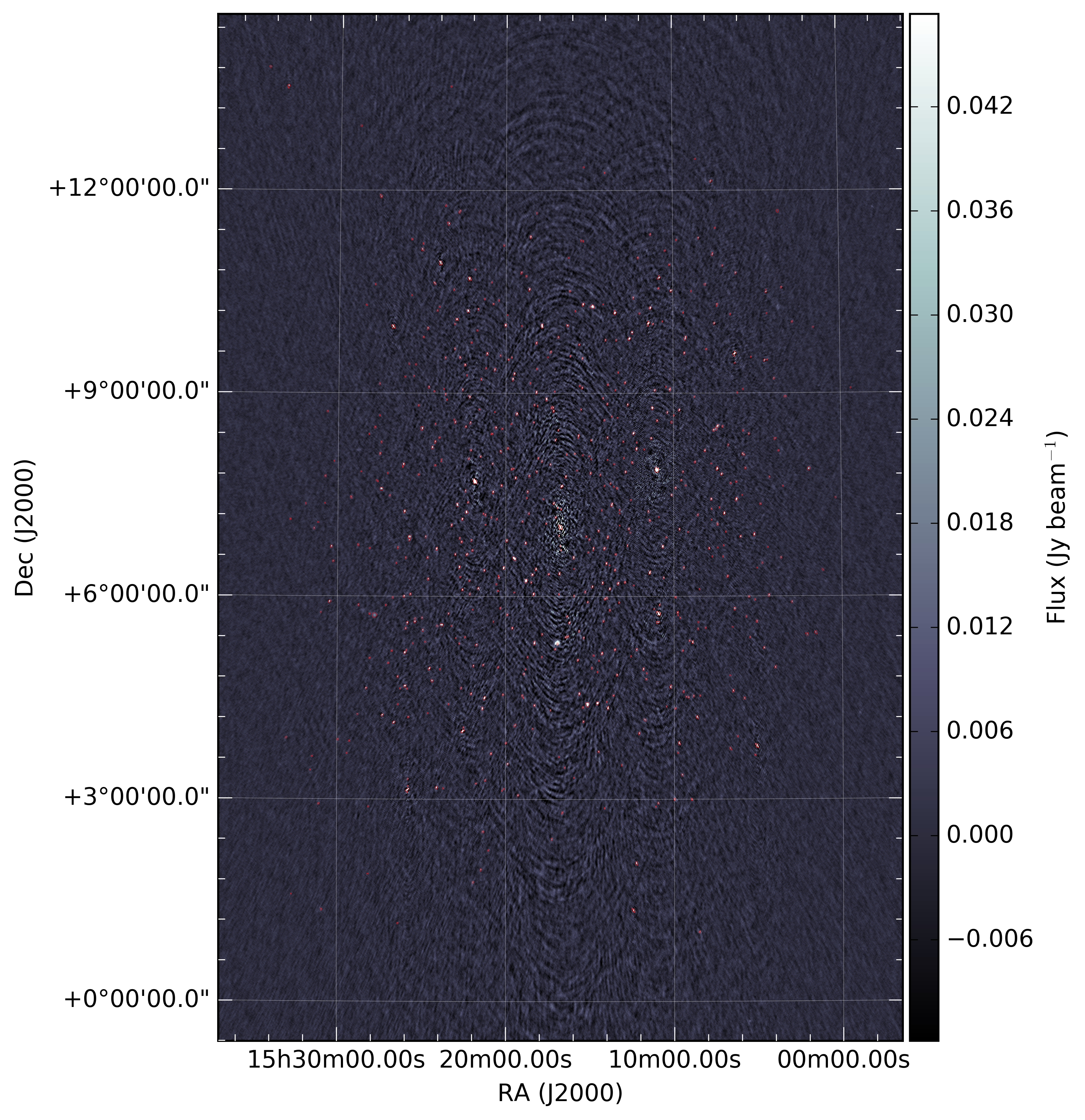
wsclean_highImage the data with WSClean to make the high-resolution images. The images will automatically be stretched along the y-axis to account for the elongation of the primary beam as a function of average elevation. A typical image at lower Declination (+7 degrees) looks like the one below.
mask_highMake masks for the high-res images. Masks are used to exclude artifacts from being included in the subtract steps.
mk_inspect_dirCreate the inspection_directory if needed.
copy_maskCopy the mask images to where we want them.
plot_im_highPlot the high-res image and mask as png files. Such an image is show above.
move_highMove the high-res images to where we want them.
create_maxsize_high_mapMake a mapfile with maximum image size.
pad_model_highPad the model images to a uniform size.
pad_mask_highPad the mask images to a uniform size.
combine_model_high_mapfileCompress the model_high mapfile.
expand_model_highExpand the model_high mapfile so that there is one entry for every band.
combine_mask_high_mapfileCompress the mask_high mapfile.
expand_mask_highExpand the mask high mapfile so that there is one entry for every band.
fits_to_bbs_highConvert high-res model images to sky models that are understood by DPPP.
make_sourcedb_highMake sourcedbs from the high-res sky models.
expand_sourcedb_highExpand the sourcedb mapfile so that there is one entry for every file.
subtract_highPredict, corrupt, and subtract the high-resolution model. The subtraction is done from the DATA column to the SUBTRACTED_DATA_HIGH column. The SUBTRACTED_DATA_HIGH column is imaged later in the
wsclean_lowstep to pick up any emission missed in the high-resolution image.select_low_sizeAdjust the low size mapfile to match the selected bands.
select_low_nwavelengthsAdjust the low nwavelengths mapfile to match the selected bands.
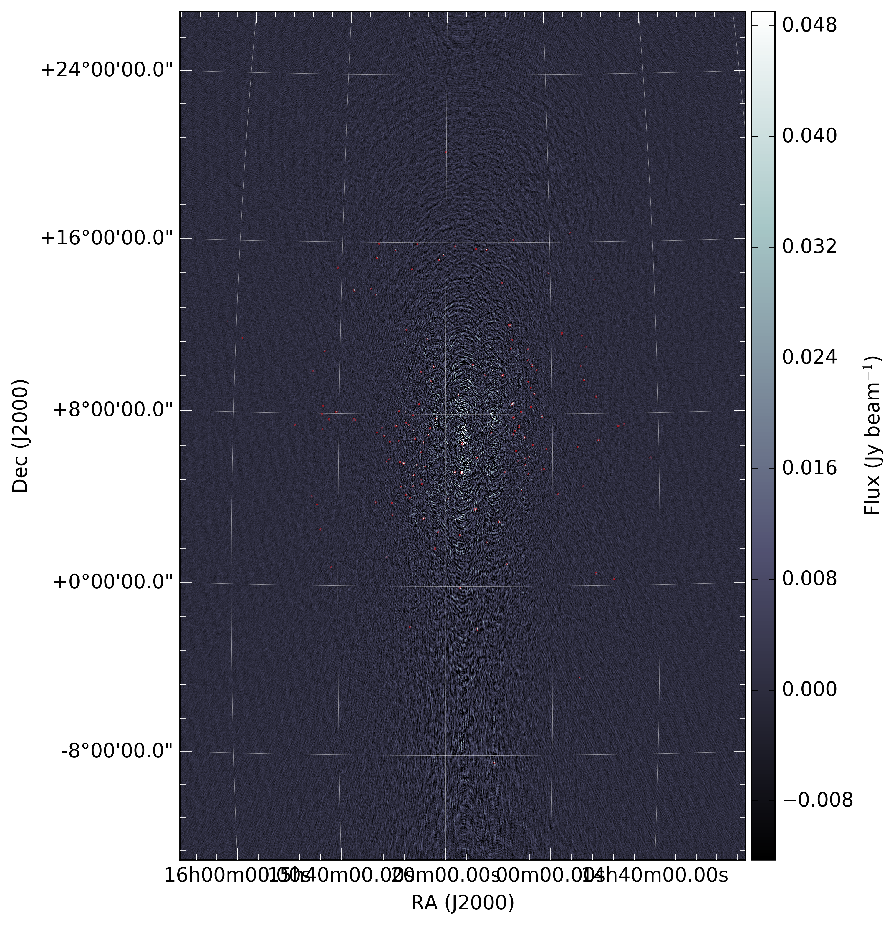
wsclean_lowImage the data (after subtraction of the high-resolution model) with WSClean to make the low-resolution images. The images will automatically be stretched along the y-axis to account for the elongation of the primary beam as a function of average elevation. A typical image at lower Declination (+7 degrees) looks like the one below.
mask_lowMake masks for the low-res images. Masks are used to exclude artifacts from being included in the subtract steps.
plot_im_lowPlot the low-res image and mask as png files. Such an image is show above.
move_lowMove the low-res images to where we want them.
create_maxsize_low_mapMake a mapfile with maximum image size.
pad_model_lowPad the model images to a uniform size.
pad_mask_lowPad the mask images to a uniform size.
combine_model_low_mapfileCompress the model_low mapfile.
expand_model_lowExpand the model_low mapfile so that there is one entry for every band.
combine_mask_low_mapfileCompress the mask_low mapfile.
expand_mask_lowExpand the mask low mapfile so that there is one entry for every band.
fits_to_bbs_lowConvert low-res model images to sky models.
make_sourcedb_lowMake sourcedbs from the low-res sky models.
expand_sourcedb_lowExpand the sourcedb mapfile so that there is one entry for every file.
subtract_lowPredict, corrupt, and subtract the low-resolution model. The subtraction is done from the SUBTRACTED_DATA_HIGH column to the SUBTRACTED_DATA_ALL column. Therefore, the SUBTRACTED_DATA_ALL column contains the final residual data needed for Factor.
mergeMerge the high-res and low-res sky models together. These sky models are used by Factor to add sources back before calibration.
copy_skymodelsCopy the merged sky models to the directory with the input data.
createmap_plotsCreate a map with the generated plots.
move_plotsMove the plots to the inpection directory.
User-defined parameter configuration
Parameters you will need to adjust
Information about the input data
! data_input_pathDirectory where your concatenated target data are stored.
! data_input_patternRegular expression pattern of all your target files. .. note:
These files should have the direction-independent calibration applied to the DATA
column (usually the ``*.pre-cal.ms`` files from the target pipeline).
Location of the software
! prefactor_directoryPath to your prefactor copy
! wsclean_executablePath to your local WSClean executable
Parameters you may need to adjust
Imaging and subtraction options
! cellsize_highres_degCellsize in degrees for high-resolution images.
! cellsize_lowres_degCellsize in degrees for low-resolution images.
! fieldsize_highresSize of the high-resolution image is this value times the FWHM of mean semi-major axis of the station beam.
! fieldsize_lowresSize of the low-resolution image is this value times the FWHM of mean semi-major axis of the station beam.
! maxlambda_highresMaximum uv-distance in lambda that will be used for the high-resolution imaging.
! maxlambda_lowresMaximum uv-distance in lambda that will be used for the low-resolution imaging.
! image_paddingHow much padding shall we add during the imaging?
! nbands_imageNumber of bands to image (spread over the full bandwidth). Larger values result in better subtraction but longer runtimes.
! min_flux_jyMinimum flux density in Jy of clean components from the high-resolution imaging to include in subtract_high step.
! idg_modeIDG mode to use: cpu or hybrid (= CPU + GPU).
! local_scratch_dirScratch directory for wsclean (can be local to the processing nodes!).
Parameters for HBA and LBA observations
At this time, only HBA data are supported.